skip to see
just the finished
art pieces
here
"Nature is the living, visible garment of God"
Johann Wolfgang von Goethe
Virginia State Parks
Seals 4 Real Travel Blog
Sailor's Creek Battlefield State Park

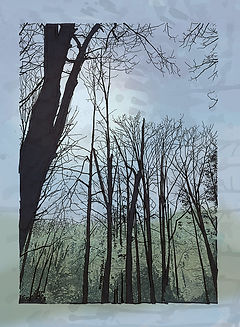
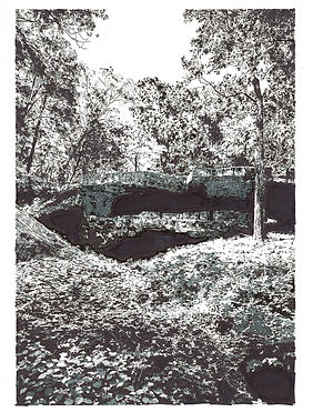
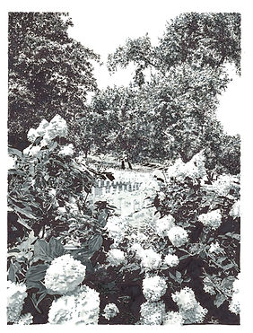
January 1, 2025 • We decided to take a hike to start the new year. The kids were up in New York with Mimi for the holiday, so it was just Lauren and me. There's apparently quite a number of people that start the new year hiking at the parks - they call it "First Day Hikes." We maybe could have gotten a sticker or a patch or something, but we didn't know that at the time. It was a little cold, but it seemed like a great way to kick off 2025. Plus our neighbor, Denise, who has accumulated a nice collection of my artwork, had inspired me to start a new series of art by suggesting I try to sell my stuff in the park gift shops. (Her kid, Katerina, is studying to become a Park Ranger and worked at Natural Tunnel State Park way way out west in Scott County last summer where me and the girls visited her and learned about Woodboogers...and now I suppose we'll have to go back...) Anyway, me being me, I turned that little suggestion into a giant mega-project, and decided I would visit all 43 Virginia State Parks and do a piece for each one. Pretty ambitious - but it would combine two of my favorite things - family time in the parks, and image making - so it made a lot of sense. And what better day to start than New Year's Day?


I wanted to start at one of the smaller parks, and not travel too far. I also didn't want to hit the larger parks without the kids plus I wanted to wait for better weather and greener foliage. Pocahontas is the closest park to our house, but we've been there a gazillion times so that would have been an anti-climactic beginning. So amongst the other fairly close-by parks there's a trio right off U.S. Route 460 that includes Sailor's Creek. (I was actually thinking way too ambitiously that we could hit one or two of the others, lol.) So, Lauren and I head out to hike Sailor's Creek Battlefield. I took about 25 pictures around the park, intending to create a mixed media digital painting in a similar fashion to my recent Richmond and HorrorTecture series. I hand-draw the architecture, or in this case the landscape, with Micron pens, Sharpie and alcohol markers, as well as the abstract things, also with Sharpie markers, and then scan them into the Mac to combine them with (also) hand-made watercolor textures. For these pieces (as well as for the RA27 and L&S series) the watercolor textures were (mostly) created for me by Meaghan and Madison.
Here's what the black & white abstracts and drawings look like:


As far as the park goes, here is some basic info as provided on the dcr.virginia.gov website:
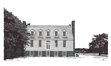
"On April 6, 1865, Confederate General Robert E Lee’s Army of Northern Virginia wearily trudged its way through Amelia County in hopes of reaching greatly needed supplies at Farmville, Virginia. At Sailor’s Creek, Union General Ulysses S. Grant’s Union forces successfully cut off the line of retreat and attacked the rear guard. The result was an overwhelming Union victory, having captured wagons, artillery, approximately 7,700 combatants, and 8 Confederate generals. 72 hours later, General Lee would be surrendering the remainder of his army to General Grant at the village of Appomattox Court House, thus effectively ending the fighting in Virginia.
The staff at Sailor’s Creek present living history programs and events throughout the year at various times. Motorists traveling along Lee’s Retreat may learn more about the Appomattox Campaign and the battle through interpretive signs along the route. Tours of the historic Overton-Hillsman house, which was used by both armies as a field hospital, can be arranged upon request."
After Lauren and I hiked about the 370 some-odd acres, we headed over to Farmville and had a nice lunch at Macado's. And that's how we started 2025 - and this enormous new art project and family goal of hitting 43 state parks...in a year...or two...
Oh...PS...me being me...I didn't do just one piece...I kinda kept going. I was having fun. Here the finished pieces so far:


Powhatan State Park

February 1, 2025 • Yeah...43 parks in a year or two? Probably not. A whole month later and we finally visited our second park. Clearly this little hiking art project is gonna maybe take me more than a couple years, lol. Still kinda cold and barren out there so we kept our venture pretty close to home again, shooting up to Powhatan State Park, about 45 minutes north of home.


Powhatan County, named for Chief Powhatan of the Powhatan Confederacy, lies between the James River to the north and the Appomattox River to the south. Chief Powhatan, by the way, was the father of Pocahontas. The State Park is in the northwest corner of the county and is situated on the bank of the James.
In the shade on February 1st, it was chilly enough to bundle up with double jackets and hoods - but the ground was squoooshy enough to be bothersome. Of course we were not wearing appropriate hiking footwear...nah, sneakers all around for these intrepid wanderers. The mud didn't just redecorate our shoes but more than once leaked right on through giving reason for pretty much on-going complaining. But our cold, wet feet didn't stop us, we made a fairly complete circle around the 1500-some-odd acres and got a few good shots, enough to base some drawings on.


Despite protestations, we made it to the historic little grave yard tucked away in a shady grove of trees. The cemetery features traditional burial practices, field stones, and graves, marking the resting places of former residents dating from the 1840's.
After our visit to the park, we happily made our way to the Goochland Restaurant, a favorite in the area since 1950. The service and the other patrons were so friendly, it felt like we were family. And the food was precisely what one would expect from a little family-owned greasy spoon on the side of a country road - fresh, tasty and comforting.


"I lift my eyes to the mountains -
where does my help come from?
My help comes from the LORD,
the Maker of heaven and earth."
Psalm 121:1-2
Grayson Highlands State Park
Hungry Mother State Park

April 18-19, 2025 • It took us over two months to get back on track this time - but at least we hit two parks in one weekend! The original impetus for this excursion was an artist's talk at the Arts Depot in Abingdon, VA. But Abingdon is more than four hours away, and that's a long trip to see any artist. So I devised a little plan to head out west for the weekend, stay in the area, see the artist, and hit a park or two. As the weekend drew close, we realized that Lauren wouldn't be able to come with us due to being on call for work - so we invited our neighbor, Katerina - the soon-to-be Park Ranger mentioned earlier on this page. Abingdon was pretty close to where she had lived and worked last year and she was actually familiar with the area and even the parks we visited. So it kinda sucked that Lauren couldn't make it, but Katie was an advantageous addition and she's basically family. (Pretty sure her parents, Denise and Adam, will be with us on one of these adventures eventually - they all hit the parks hard.) So we took off on Good Friday to spend a couple days in the Blue Ridge Mountains of western Virginia.


First stop - Grayson Highlands, located in Grayson County, near Virginia's two highest mountains, Whitecap Mountain (5,520 feet) and Mount Rogers (5,729 feet.) The County was named for William Grayson, a delegate to the Continental Congress and subsequently one of Virginia's first two U.S. Senators. The state park was established in 1965 and spans a tad over 4,500 acres. The Appalachian Trail as well as the Virginia Highlands Horse Trail run through the park. A herd of wild ponies graze the balds (mountain summits or crests in the Appalachians covered primarily by thick vegetation of native grasses or shrubs occurring in areas where heavy forest growth would be expected) - but we didn't see any - ponies that is - we saw and walked the balds, tactfully avoiding the piles of evidence of the ponies left behind by the ponies. A big section of the park was unfortunately closed the day of our visit, including the visitor center, so Katie wasn't able to collect her pin. :( That evening we went to a neat bar & grill in Abingdon called Brisket & Bourbon where the food and drink and live entertainment were great. (We don't really know what the significance of the pig on the rail is but we all loved him.)


more drawings and art from Grayson Highlands coming "soon"
On day two we got up kinda early and head out to Hungry Mother, which was approximately 45 minutes (of awesome mountain backroads) east of our hotel and Abingdon. Hungry Mother is one of Katie's favorite parks and once we were there it was very understandable why she was excited to get there again. As one of the original six Virginia State Parks (opening in 1936,) Hungry Mother is known for beautiful woodlands and a placid 108-acre lake in the heart of the mountains. The park has a sandy beach with a bathhouse, boat rentals, a boat launch and a universally accessible fishing pier. (As per the dcr.virginia.gov website:) "Legend has it that a pioneer named Molly Marley and her small child were captured by a Native American tribe and taken to their mountain camp. Molly and her little one eventually escaped and wandered through the woods foraging for food and searching for shelter. One day Molly collapsed from exhaustion, and the youngster continued along the creek until help was found. The only words the child could utter were “Hungry Mother.” A search party later found Molly dead at the foot of the mountain near the creek. The mountain went on to be called Molly’s Knob and the stream Hungry Mother Creek. In the 1930s, the Civilian Conservation Corps developed the park, and the creek was dammed to form the lake. The name of the park is wrapped in its own mystery. Originally it was to be called Forest Lake. The name was changed to Southwest Virginia Lake and then to Hungry Mother State Park not long before the park opened. The debate over the legend and the park name continues to this day."


additional drawings from Hungry Mother coming "soon"
Hungry Mother is truly a wonderful oasis. As mentioned, it has a stunning mountain lake with abundant facilities to enjoy, as well as both leisurely and challenging hiking trails around the lake and campgrounds and up to the peak of Molly's Knob (3,270 feet.) We did get to the visitors' center which was quite modern and well appointed. Katie got her pin and I got myself a coffee mug. After a few good hours in the park we were all pretty much starving but we faced the challenge of getting back to Abingdon in time for the artist's talk which we had come for. Growling stomachs prevailed so we head into Marion to grab a bite to eat at the always top notch Macado's Restaurant. Just before indulging in a little too much junk food we snuck into Blue Ridge Comics & Toys across the street where I acquired a few ReAction Super7 collectible action figures to add to the hanging display around me in my office. Overall a really super trip. Of course, we totally missed the artist's talk that was the original catalyst for the weekend, but hitting two parks in two days was well worth the journey and the disappointing omission of going to meet Charles Vess. Oh, that's the artist we were going to see in Abingdon. He's an amazing and multiple award-winning fantasy illustrator who lives out in Abingdon. I can totally see why he chose this pastoral corner of Virginia. It's not hard to imagine the faeries, wood folk and mythical creatures he so passionately illuminates actually populating the forests surrounding this truly beautiful town. In the fall, Meaghan will be heading to vcuarts, which happens to be Mr Vess' alma mater. Perhaps someday Meaghan will give artist's talks.


more art from Hungry Mother coming "soon"
"Swarms of living creatures will live where the river flows.
There will be large numbers of fish, because this water
flows there and makes the salt water fresh; so where
the river flows everything will live."
Ezekiel 47:9
Chippokes State Park
May 17, 2025 • We go to Busch Gardens in Williamsburg all the time. We're kinda theme park nuts, and Busch Gardens is literally the world's most beautiful. (So says the National Amusement Park Historical Association...for 34 years.) It's about 90 minutes away, depending on traffic, and we purchased a membership so we use it as a default when we need something to do. Plus it's a great place to entertain out-of-town guests when they come to visit. If you've never been, it's sorta like an EPCOT with big rides. If you've never been to EPCOT, that's sorta like a world's fair with Disney characters. We also visit Colonial Williamsburg often, for the history, the shops, and the dining. (I'll probably do a series of architectural renderings of the historic buildings of Colonial Williamsburg at some point.) Anyway, this is about Chippokes, not Busch Gardens (although now that I'm thinking about it, I should probably draw Busch Gardens too.) Point is, the Food & Wine Festival at Busch Gardens was, in fact, the "excuse" to visit Chippokes. Not that we need an excuse, but I usually don't like to go anywhere with just one reason to go. So hitting a State Park and a theme park in one drive gets me outta the house with more verve than just one or the other.


It was just me, Meaghan, and Madi again but I can't remember why Lauren couldn't come along. I think she was helping out with a work event. Although we knew that Chippokes is situated on the James River, I was honestly a little surprised by the beachiness of the beach. It was like a real soft sandy beach, like a Long Island beach. Like where I grew up and spent a ton of time at with my mom. Especially like Sunken Meadow (NY) State Park on the north shore. At Chippokes, we spent a bit of time sifting through the sand hoping to find a sharks tooth, which you can take home. The beaches are covered in fossils, which you cannot take home. We did find quite a few creature bones and crabs, but we didn't want to take any of them home.
Chippokes is one of the oldest continually farmed plantations in the country. Established in 1619 by English Captain William Powell, a Lieutenant Governor of Jamestown, this 1,400-acre farm located opposite Jamestown Island, has been the site of an active agricultural operation for more than four centuries. Powell named the plantation after Choapoke, an Algonquian Indian Chief who was friendly to the English settlers in Jamestown. After Powell's death Chippokes changed hands frequently, most times serving as a secondary plantation managed by overseers or farmed by tenants. There are many historically significant buildings and structures that can still be found on the property, including the two plantation houses, original plantation outbuildings, slave quarters, farm buildings and several colonial period archeological sites. In 1918 Mr. and Mrs. Victor Stewart purchased Chippokes, and lived there until 1967. Upon her death, Mrs. Stewart willed the plantation to the Commonwealth of Virginia for the establishment of a museum of Virginia's agricultural history. (History from the Friends of Chippokes State Park website.)


After walking the shoreline, which we shared with a few optimistic fishermen as well as a few intrepid bathers (mostly youngsters and a few snorkeling teens, also searching for shark teeth,) we drove up onto the plantation proper to visit the Farm and Forestry Museum and take a guided tour of the Jones-Stewart Mansion. Madi inquired of our tour guide whether or not the mansion was haunted. The reply was delivered with a wry grin, "Well," the guide said, "I have heard a few things."
We were a wee bit tired and hangry after all that exploring, so we head out for a quick visit to the aforementioned Busch Gardens to take advantage of some Food & Wine Festival sampler coupons that we had. We took the surprisingly free Jamestown-Scotland Ferry across the river and grabbed some "Loco Moco" at the Hawaii pavilion and a superb taco from Mexico. We all do thoroughly enjoy and highly recommend the Food & Wine Festival, but it was ridiculously crowded that day. So we didn't stay very long, and to Madi's dismay didn't ride any rides. (It's ok, we went back a couple of weeks later with Mimi (my mom) in tow, and hit some of the big rides and indulged in more of the Festival.) Sadly, we never did find a shark tooth at Chippokes. :(


more drawings & art from Chippokes coming "soon"
a little detour to Arkansas, USA
June 7-14, 2025 • When we told people that we were going to Arkansas for vacation, most folks asked, "Why?" To be honest, we didn't really know why. There were some procrastination and logistical factors, but really - the not knowing why became the reason. Like I mentioned earlier, we're theme park aficionados, most especially Walt Disney World in Florida. Unfortunately, over the years, as the crowds increased exponentially and the required planning eclipsed the spontaneity of running through the Magic Kingdom from (no so long) line to line, our dedication to the most magical place on earth faded. (Don't get me wrong...we're still Disney freaks, it's just a whole different mind space for us now.) So we were looking to go somewhere where you didn't have to plan every meal six months in advance. We wanted to relax. And we wanted to see something real. And Arkansas paid off. We loved it. There was nothing to do - and we did it all! Of course, everything that we did was, like, an hour or more away, but just driving was exhilarating. Cruising through the mountains, the farms, the little towns. I kept thinking about Neil Peart's travelogue prose from several of his books, traversing the small roadways across America, experiencing the beauty of this place, and interacting with the people. The real people. You know what? It turns out that Americans are not the caricatures portrayed with vitriol and disdain on the nightly news. In the middle of East Bumbleflip Nowhere, we met all sorts of Americans, white ones, black ones, Asian Americans, Mexican Americans, gay folk, straight folk, atheists, Christians, hardworking, vacationing, rich and poor. Some of 'em had MAGA hats, some of 'em wore "F Trump" tee shirts, but as they went about their lives, and we went about our relaxing, I felt an honest kinship with all of them, and a renewed love for America. There's truth in a simple expression, "people don't suck - groups of people suck." Perhaps we should stop looking at each other as groups but as people. Perhaps everyone should go to Arkansas for vacation. Just sayin'
So...what did we do while doing nothing?


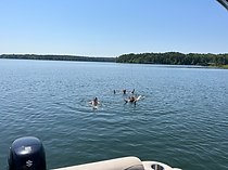


Well, we saw some BIG chairs in Mountain View, where we also had some fine milk shakes. Not sure why they have the BIG chairs but they're apparently the "Folk Music Capital of the World." Who knew? We went boating and swimming on Greers Ferry Lake. We went to The Museum of Automobiles in Morrilton, where they have the General Lee from "The Dukes of Hazzard" and the DeLorean from "Back to the Future." (Yeah, yeah, just replicas.) We went caving at Talking Rocks Cavern near Branson, MO. (So yes, we went into Branson to ride some mountain coasters, eat at Jackie B Goode's Uptown Cafe, and shop for some tacky souvenirs.) We stopped at numerous roadside natural wonders. Not on any map or in any guidebook, just beautiful little spots to stop on the side of the road and look at stuff. We saw a dam. We walked into art at the AMFA in Little Rock. We visited the MacArthur Museum of Arkansas Military History, next to the art museum, which, by the way, is the birthplace of General Douglas MacArthur. And to surprisingly little protestations, we went antiquing. (One of my favorite things to do. The wife and kids? Not so much.) Plus a lot of pool-side sipping while the kids swam and I was working on designing a book about the band Asia by Matt Herring from Monarch Books. We also spent a day at the Little Rock Zoo, and we went to see the Natural Bridge of Arkansas. Super relaxing, all of it.


check back "soon" - more words, plus some drawings & art from Arkansas are coming
Arlington National Cemetery
June 19, 2025 • We live about 2-3 hours from Washington, DC (depending on traffic.) So taking a day trip up to the capital is fairly common for us. Maybe a couple times a year. Obviously there's a million things to see in all of the museums and we're pretty patriotic so just being there makes us happy. We started this particular Saturday without a plan (shocking, I know) and kinda head out on the road without a destination. We weren't quite sure how the weather was going to be - there were some threatening clouds but we were hoping that they would end up providing a bit of relief from the oppressive summer heat that we (and probably most of you) were dealing with even this early this summer. We considered several of the State Parks, weighing the pros and cons, mostly regarding the temperature, but also potential crowds and such. Somehow we decided to shoot up to DC figuring there's always something to do and always good food, even if just from one of the food trucks on the mall.


check back "soon" - more words, drawings & art from Arlington are coming
Twin Lakes State Park
August 23, 2025 • Almost nine months in and we finally hit park number six! As soon as I woke up I knew we had to be outside this day. The temperatures here still could be, even should still be stifling in August, but this day's weather was perfect. In typical us fashion we head out the door not even knowing where we were going. We had to drop something off at Lauren's parents' house which sent us heading in a somewhat westerly direction. We knew that there are three parks in a little cluster not too far out on Route 460 (near where we visited Sailor's Creek Battlefield on New Year's Day.) So we picked one and off we went towards Twin Lakes. There was one big gaping hole in our party today. Meaghan had already moved into her dorm and started classes at VCU this past week, so she wouldn't be with us. I suppose it's always bitter-sweet when a kid moves out and onward. We all juggled our mixed emotions watching Meaghan pack up, move out, and start to chase her goal of becoming an art educator. Madi's feelings, however, were generally excitement as she claimed and then took over the largest bedroom in the house. But even she was already missing her big sis. So, with one empty seat, and Lauren (mostly) holding back her tears, off we went to Twin Lakes.


check back "soon" - more words, drawings & art from Twin Lakes are coming
including an explanation of that cute little pup
High Bridge Trail State Park
September 1, 2025 (Happy Birthday Rob!) • In the past, and for fifteen years, Labor Day weekend to me meant gearing up for and then working the Greenlawn Volunteer Fire Department's Fireman's Fair. Lauren and I were just talking about how either one of us could probably write a book about the things we've seen and done, in EMS and firefighting for both of us, and now in law enforcement for Lauren and organ donation/transplant for myself. My EMS/medical career began when I joined the GFD in 1994.
I originally joined because I had always wanted to drive the "BRTs" - the Big Red Trucks. Like many young boys, I had an obsession with fire engines as a kid, totally exacerbated by the TV show "Emergency!" Historically, that show has been attributed with a great many people entering the, at the time, newly formed EMS field. Before LA County piloted and subsequently popularized paramedics with that show, emergency medicine was pretty much only for combat medics on the fields of war. Of course, while I couldn't have realized the eventual significance of the show at the time, neither for myself nor EMS in general, I surely was aware that Squad 51 was friggin' cool. To the great consternation of my neighbors on Orton Drive in the late 70's and early 80's, I could often be heard loudly reenacting Johnny and Roy's adventures with Matchbox toys or by bicycle, howling out siren sounds all around the 'hood. As soon as I saw that show, I knew I was going to be a paramedic. At some point, however, in junior high or high school, I suppose, I got distracted by this art thing. Ultimately though, it was art that actually brought me back to becoming a firefighter and a paramedic. You see, around the time that I moved into Greenlawn, one of my jobs was inking backgrounds for comic books. Therefore I was spending a lot of daytime hours alone, at home, sitting in front of a drawing table. Pretty monotonous stuff. I'm not sure if they still do this, but back then, when there was an emergency, the volunteers were summoned by siren. Essentially variations of air raid sirens, the dispatchers would sound different patterns reflecting different types of alarms. This system was eventually supplemented (and maybe replaced?) with a more modern (and quieter) pager system. But in Greenlawn, in 1994, while I was inking pages of Archie Comics, I kept hearing the sirens wail, and that's what reawakened my interest in BRTs and paramedics.
Anyhoo, this is about hiking High Bridge Trail, not the Greenlawn Fire Department. But in the early morning, while I was having coffee and before we decided to go for a hike, I was browsing the innerwebs and was reminded that the fair was this weekend.


check back "soon" - more words about High Bridge Trail, as well as drawings & art are coming
Lake Anna State Park
September 6, 2025


check back "soon" - Lake Anna words, drawings & art are coming
short trip to Walt Disney World
October 10, 2025 • Clearly, as this "project" moves onward, I'm starting to include more than the VA State Parks. If only the parks were included, there wouldn't be as much to talk and draw about. And we do do a lot of things and go a lot of places. So when we go out, and if I take pictures and draw something about a somewhere, I'm gonna put it in here...the Seals 4 Real travel blog.
As I had mentioned up above, and something anyone who knows us knows, we're pretty big fans of Walt Disney World. I honestly have no idea how many times I've been. Pretty sure my first trip was either late 1975 or early 1976. My mom had recently achieved sobriety after joining AA and our trip was part of her celebration. (BTW, we're celebrating her 50 years of sobriety this November!)
I have some of the original souvenirs from that trip, and they are all about the American Bicentennial, so I'm guessing we were there in '76. A tale Mimi will often tell is that the first ride I insisted on taking was the parking lot tram. (Looked like a good ride to me!) If I'm remembering correctly, I was also delighted the first time I saw actual "dinosaur trees." Well, that's what palm trees looked like to me - dinosaur trees! Not sure when my next trip was but I know it was after EPCOT opened, and I think it was after my grandmother had passed, so probably 1983/1984. My mother's cousin (who is also my Godfather) Gerry took me. What I remember most about that visit was that it was HOT.
Many years later, maybe 1990-91, I had moved down to a tiny little place called Lauderdale by the Sea. Me and my buddy Frank had driven my Bronco towing a U-Haul full of my stuff down but on the way back were forced to detour off of I-95 and "accidentally" found our way to Disney World. I usually point to this spontaneous trip as the true beginning of my true love of the Most Magical Place on Earth. Frank and I stayed at the (then new) Disney Swan at which we arrived without reservations but were able to walk in and get a room. For the next two days we were able to park-hop all three theme parks (no Animal Kingdom yet) and pretty much get on every ride and attraction. (Try that now!) I was hooked! Over the next several decades, after moving back north to New York and then to Virginia, I continued to travel down to Florida every chance I had to enjoy the resorts and the parks. Along the way my love for all things Walt Disney World was contagiously shared with friends and family and likely passed down to and through Rob, Andrea, Dylan, Meaghan, and Madison - and I hope to someday soon be walking up Main Street USA with Nora and Charlotte.
Anyway, back to 2025. Our wedding anniversary is October 12th, and Madi's 12th birthday is October 18th. This year I knew that I was going to be tied up selling HorrorTecture at Nightmare Weekend for Madi's birthday weekend. Plus, I was away on business for almost two weeks this month. So we planned a little birthday surprise for Madi, and an anniversary trip for us. I arranged for Lauren and Madison to shoot down to meet me in Orlando and spend a few days at Disney. Me and Lauren have been hitting the annual EPCOT International Food & Wine Festival on our anniversary every October for years. Probably since before we were even married. For this special weekend, Lauren woke Madison up to go to school on Friday, but instead drove to the airport. Each step of the trip was another confusing surprise to Madi. I don't think it really started to sink in, and we're not sure she was even totally awake until I picked them up at the Orlando airport, and then more so when we drove under the Walt Disney World arch. She finally got it, but probably still couldn't believe it, when we walked into Hollywood Studios. I thrive on spontaneity. Even when we're talking flights and theme parks.
The parks were ridiculously crowded this weekend, which puts me in a way less than optimal mood, plus our first meal at the park was extremely underwhelming - but once we got on to the Tower of Terror...we were pretty much home...


check back "soon" - more words, plus drawings & art about Disney are coming
Pocahontas State Park
November 2, 2025 • Pocahontas was a Native American woman belonging to the Powhatan people, notable for her association with the colonial settlement at Jamestown, Virginia. She was the daughter of Wahunsenacawh, the paramount chief of a network of tributary tribes in the Tsenacommacah (known in English as the Powhatan Confederacy), encompassing the Tidewater region of what is today the U.S. state of Virginia. Pocahontas was captured and held for ransom by English colonists during hostilities in 1613. During her captivity, she was encouraged to convert to Christianity and was baptized under the name Rebecca. She married the tobacco planter John Rolfe in April 1614 at the age of about 17 or 18, and she bore their son, Thomas Rolfe, in January 1615.
In 1616, the Rolfes travelled to London, where Pocahontas was presented to English society as an example of the "civilized savage" in hopes of stimulating investment in Jamestown. Pocahontas became a celebrity, was elegantly fêted, and attended a masque at Whitehall Palace. In 1617, the Rolfes intended to sail for Virginia, but Pocahontas died at Gravesend, Kent, England, of unknown causes, aged 20 or 21. She was buried in St George's Church, Gravesend; her grave's exact location is unknown because the church was rebuilt after being destroyed by a fire. Her story has been romanticized over the years, many aspects of which are fictional. (paraphrased from the Wikipedia article)
Pocahontas State Park is located right here in Chesterfield County, about 20 minutes from our home. The park was laid out in 1946 by the Civilian Conservation Corps along the Swift Creek, and at just over 7,900 acres it is our largest state park. The park boasts over 90 miles of trails, all of which, I'm sorry to say, we have not yet hiked. According to the Virginia DCR website, Pocahontas sees over a million visitors every year. Although the park is named after Chief Powhatan's daughter, and Disney Princess, Pocahontas, there is no evidence that the Disney movie was actually filmed in the park.
On a perfectly crisp but not yet cold autumn afternoon, after enjoying a wonderful Multi-Gen morning of worship at Swift Creek Baptist Church, Lauren and I meandered over to our hometown park for a brisk two mile trek around Beaver Lake, one of our favorite places here in Chesterfield. Madi was hangin' with Grandma (read as shopping) - and Meaghan had stayed in the city for the weekend to partake of the Halloween festivities around VCU. So just the two of us (for the first time since we started this little project) hit the trail as the sun just started to settle behind the trees...
check back "soon" - more words, pics, drawings & art about Pocahontas are coming
York River State Park
November 28, 2025 • What better way to work off the turkey than a walk on the York?
check back "soon" - more words, pics, drawings & art about York River are coming
Pocahontas State Park (yes, again)
January 1, 2026 • One year ago today, Lauren and I discovered the "First Day Hikes" program in the Virginia State Parks which coincided with this new adventure venture of walking the parks then drawing, arting, and blogging about our treks. Back in April I had mentioned that our friends from across the street would more than likely eventually join us 'cause they're always enjoying the parks, and their daughter is working towards becoming a Park Ranger. (She had been our guide at Hungry Mother & Grayson Highlands.) Well, it only took a year, but on New Years Day, after celebrating the ball drop together the Eve prior, Denise and Adam as well as Katie joined Lauren, Meaghan, Madi and me for a short hike in our most local Pocahontas State Park. We didn't set out until after 10 but it was still a little chilly so we bundled up with layers, hats, and gloves. Adam and I had been chatting about biking the parks the night before and continued as we walked. He was clearly knowledgeable and familiar with the many bike trails at Pocahontas as he and the family had rode more than a few of the 44+ miles of mountain bike trails (plus 64+ miles of gravel fire roads.) He mentioned that the bike trails attract visitors from around the country and is easy to see why. There were a good number of bikers and many hikers on the trails, most exchanging a friendly "happy new year" greeting as they passed. I am pleased to report that in addition to spending some great time in a great place with some great friends, we did collect our complimentary "First Day Hikes" sticker from the Ranger at the pretty crowded Visitor Center.


photos by Lauren


photos by Adam Dowgiallo
check back "soon" - more words, pics, drawings & art about Pocahontas are coming
Bear Creek Lake State Park
January 3, 2026 • (Happy Birthday David!) Two parks within three days. Now we're talking. Or walking, actually. 35°F but Lauren was motivated to get out and get moving, so I peeled myself away from making abstract digital paintings on the Mac and off we went.